|
 |
|
| Hiper |
 |

|
|
 |
HIPer Pro
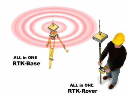
The revolutionary HiPer® Pro integrated GPS+ receiver/antenna joins the successful HiPer lineup, bringing wireless technology and a long range UHF radio system for ultimate convenience.
The HiPer® Pro provides the completely cable-free system design and operational advantages, with the added benefit of extended working range. With completely cable free; no more cables to break and no more wasted time with difficult base receiver setups. Just 5 components in one compact carrying case, a tripod and pole. That’s all you need.
No Of Items |
Hiper Pro (One compact carrying case) |
1 |
Geodetic antenna |
2 |
Power supply |
3 |
Receiver |
4 |
RTK Base station |
5 |
UHF radio |
HiPer Pro features:
- Compact, lightweight design.
- Dual frequency, dual-constellation RTK GPS+ tracking.
- 24 GPS + 11 GLONASS Satellites
- Fully integrated receiver/antenna.
- Integrated Bluetooth communication
- Long range UHF radio – Up to 4mi. coverage!
- Topsurv software - One Controller Software for All
- Totally cable free solution
|
|
The HiPer® Pro utilizes advanced Bluetooth® wireless technology to give you a system free of the messy cables found at many base stations. No more hassles of dealing with tangled, fragile cables from external batteries, antennas, and RTK adios because the wireless HiPer Pro provides a complete, integrated RTK GPS system! With HiPer Pro, there's less equipment to carry into the field, and less to forget back at the office. It doesn't get any easier!
In addition to the long range and wireless technology of the HiPer Pro, it also incorporates Topcon's industry-leading GPS+GLONASS satellite tracking echnolgy. That means more satellite coverage, increased performance, and improved precision over GPS-only systems! No more waiting, worrying and wasting time for satellite coverage.
Specifications
Description |
40 channel integrated GPS receiver/antenna with
MINTER interface. |
Tracking Specifications
Tracking Channels
Signals Tracked |
standard: 40 L1 GPS (20 GPS L1+L2 on Cinderella* days)
optional: 20 GPS L1+L2 (GD), GPS L1+GLONASS (GG), 20 GPS L1+L2+GLONASS (GGD)
L1/L2 C/A and P Code & Carrier and GLONASS
|
Performance Specifications
Static, Rapid Static
RTK
|
Horizontal: 3mm+ 0.5ppm (x baseline length)
Vertical: 5mm+ 0.5ppm (x baseline length)
Horizontal: 10mm+ 1.0ppm
Vertical: 15mm+ 1.0ppm
|
Power Specifications
Battery
Operating Time
External power input
Power consumption |
Internal Lithium-Ion batteries plus 1 external power port
14+ hours (10 hrs TX)
6 to 28 volts DC
Less than 4.2 watts
|
Environmental Specifications
Enclosure
Operating Temperature
Dimensions
Weight |
Aluminum extrusion, waterproof
-30°C to 60°C / -22°F to 140° F
W: 159 x H: 172 x D: 88 mm (6.25" x 6.75" x 3.5")
1.65 kg / 3.64 lbs
|
GPS Antenna Specifications
GPS Antenna
Antenna Type
Ground Plane |
Integrated
Center-mount UHF antenna
Antenna on a flat ground plane
|
Radio Specifications
Radio Type
Power Output
CDPD & GSM Modem |
Internal Tx/Rx UHF (Selectable frequency range)
1.0W/0.25W (selectable)
Optional Accessory
|
Wireless Communication
Communication |
Bluetooth® version 1.1 comp.**†
|
I/O
Communication Ports
Other I/O Signals
Status Indicator
Control & Display Unit |
2x serial (RS232)
1pps, Event Marker
4x3-color LEDs (Green, Red, Yellow), two-function keys (MINTER)
External field controller
|
Memory & Recording
Raw Data Recording
Data Type |
1Hz ( Up to 20 times per second (20Hz) by option )
Code and Carrier from L1 and L2, GPS and GLONASS
|
Data Input/Output
Real time data outputs
Other outputs
Output rate |
RTCM SC104 version 2.1, 2.2, 2.3, CMR, CMR+
NMEA 0183 version 2.2
TPS format
Up to 20 times per second (20Hz)
|
Specifications are subject to change without notice. Performance sp ecifications assume a minimum of 6 GPS or 7 GPs/GLONASS satellites above 15 degrees in elevation and adherence to procedures recommended by TPS in the appropriate manuals. In areas of high multipath, during periods of high PDOP and during periods of high Ionospheric activity performance may be degraded. Robust checking procedures are highly recommended in areas of extreme multipath or under dense foliage.
* Cinderella feature activates full receiver reception at GPS midnight every other Tuesday for 24 hours.
** Bluetooth® type approvals are country specific. Please contact your Topcon representative for more information.
† The Bluetooth word mark and logos are owned by the Bluetooth SIG, Inc. and any use of such marks by Topcon Positioning Systems, Inc. is under license. Other trademarks and trade names are those of their respective owners.
|