|
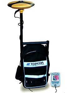
Topcon's new GMS-100 GIS data collection system
is designed to make the most of your time in the field no
matter what your level of GIS expertise. By combining ESRI's
ArcPad software with a precision GPS receiver and real-time
differential correction, the GMS-100 allows you to literally
take your GIS into the field to make data collection more
accurate and efficient. From natural resource mapping to
building and maintaining spatial databases for large utilities,
the GMS-100 is no ordinary GIS package.
The Topcon system lets you map virtually any
type of feature you encounter-points, lines, and areas quickly
and accurately. With ArcPad software you can easily create
custom data collection windows that allow you to capture
attribute data in a format fully compatible with your GIS
database. Once you've collected new features, you can immediately
see them mapped along with your GIS data. Back in the office
there's no need to convert to GIS compatible data formats
because all of your work was done in Shape file format, the
industry standard for GIS.
Accurate position data is a critical element
in collecting data to populate your GIS. With Topcon's advanced
GPS receiver technology, positions accurate to less than
sub-meter can be collected under even the most demanding
conditions including under trees or in mountainous terrain.
The real-time differential correction signals collected with
the fully integrated radios ensure that the position you
see on the data collector display reflects your actual location.
This makes navigating and relocating features a fast and
simple process.
The GMS-100 is available with a Compaq iPAQ
Pocket PC or a ruggedized data collector for work in harsh
environments. Both of these data collectors provide large,
backlit displays that can be viewed under any conditions
from full sun to complete darkness.
The Topcon tradition of accuracy, productivity
and innovation is alive in the GMS-100 system. From the rich,
intuitive ArcPad data collection software to the precision
GPS receiver, the GMS-100 will help you meet all the challenges
of building your GIS database.
|